


📝 Summary
The Universiti Teknologi Malaysia (UTM) has completed a hybrid international training program in Sabang, Indonesia, which aimed to build practical capability in ocean remote sensing and climate resilience. The program brought together students, academics, and experts from around the world to integrate satellite observations with field measurements and geospatial analysis. The initiative has strengthened international capacity building and regional networks in ocean science and geospatial technology.
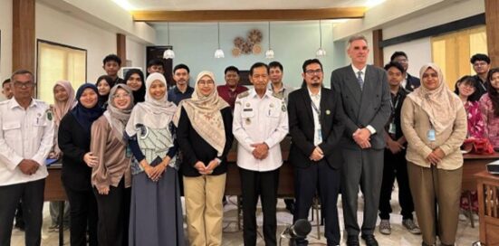
SABANG, Sep 13 – Universiti Teknologi Malaysia (UTM), through the Faculty of Built Environment and Surveying (FABU), in joint collaboration with the Pan Ocean Remote Sensing Conference (PORSEC) and Universitas Syiah Kuala (USK), has completed the UTM–PORSEC–USK Capacity Building on Ocean Remote Sensing towards Climate Resilience programme, a hybrid international training initiative that linked satellite observation, geospatial analysis, and field measurement in Banda Aceh and Sabang, Weh Island.
The programme ran from 10 August to 13 September 2026, beginning with a structured Massive Open Online Course (MOOC) online phase from 10 August to 6 September, followed by on-site training from 7 September to 13 September.
The programme was designed to build practical capability in ocean remote sensing by linking satellite observations with field measurements. It gathered students, academics, and international experts across oceanography, coastal monitoring, and disaster science, with an onsite delegation comprising UTM and USK undergraduates, graduate participants from Thailand and Vietnam, and instructors from Malaysia, Indonesia, and Italy. UTM’s participation was led by Assoc. Prof. Ts. Dr. Nurul Hazrina Idris, Chair of the UTM–PORSEC MOOC on Ocean Remote Sensing Towards Climate Resilience.
Integrating Satellite Observation with Field-Based Evidence
A defining feature of the programme was its emphasis on integrating multiple observation platforms. During the online phase, participants completed technical modules covering remote sensing, sea-surface temperature, radar altimetry, ocean colour, UAV mapping, satellite wind products, data assimilation, machine learning and scientific publication.
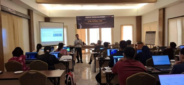
The programme emphasised an integrated workflow combining satellite observations for broad regional coverage, UAV imagery for high-resolution targeted details and in-situ marine surveys for ground-truth validation. This multi-platform approach enabled participants to leverage the complementary strengths and recognise the limitations of each observation method.
Sabang as a Field Laboratory for Coastal Observation
Sabang provided a practical setting for participants to apply the techniques introduced during the online training. On 9 September, participants commenced the field programme with coastal observations and geotagged ground-data collection, followed by cloud-based spatio-temporal analysis and radar-altimetry exercises. The activities subsequently progressed to the integration of field observations with satellite-derived datasets.
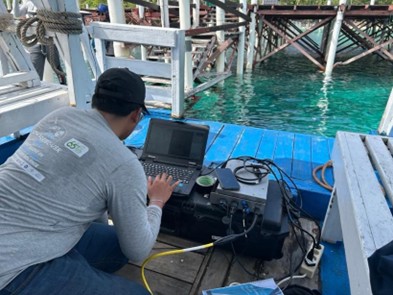
The following phase focused on marine and oceanographic surveying, including field data acquisition, quality assessment, visualisation and interpretation. Participants were also introduced to Side-Scan Sonar, which provides acoustic imagery of underwater and seabed features. The marine surveys were complemented by UAV-based coastal mapping to demonstrate how high-resolution aerial imagery enhances satellite data in coastal assessments.
Strengthening Institutional and Research Collaboration
Prior to the Sabang field programme, participants completed institutional visits across Banda Aceh, including USK’s Waste Bank, Atsiri Research Center, Tsunami and Disaster Mitigation Research Center (TDMRC), and Disaster Science postgraduate programmes. These visits connected technical ocean remote sensing with environmental sustainability, disaster-risk reduction, and resilience research. Guided by specialists from UTM, USK, and international institutions, the engagements promoted multidisciplinary academic exchange and opened pathways for future collaborations in student mobility, joint coastal studies, field campaigns and shared scientific publications.
SCOR Support Strengthens International Capacity Building
Sponsorship support from the Scientific Committee on Oceanic Research (SCOR) helped strengthen ocean-science capacity for early-career researchers by providing access to specialised marine instruments, research sites and field training. By bridging the gap between accessible online data and hands-on multi-platform observations, SCOR’s support helped reduce regional barriers to practical scientific experience. The programme also aligns with the UN Decade of Ocean Science for Sustainable Development by advancing ocean observation, international cooperation and evidence-based coastal management.
Sabang Leadership Highlights the Importance of Ocean Science
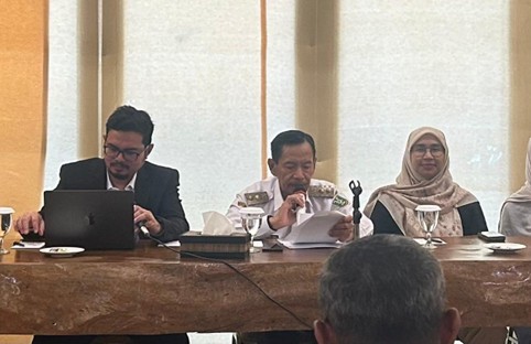
The Sabang field programme was officially opened by Deputy Mayor of Sabang, Suradji Junus, who highlighted the importance of the marine environment to the island’s economy, communities and long-term development.
“For Sabang, the ocean is not merely a part of our geographical condition, but an essential part of our identity and daily lives. Our coastal and marine environments support local livelihoods, fisheries, tourism, biodiversity, and regional development.”
Dean of the Faculty of Marine and Fisheries at USK, Assoc. Prof. Dr. Haekal Azief Haridhi, similarly emphasised the role of Earth observation in supporting evidence-based decision-making.
“To mitigate the escalating pressure of climate change, ocean remote sensing provides critical scientific evidence to support policy-making and strategic planning aimed at protecting coastal ecosystems and enhancing resilience to climate change.”
Building on UTM’s Established Ocean Remote Sensing Programme
The 2026 programme builds upon a capacity-building initiative progressively developed through UTM and PORSEC. Assoc. Prof. Ts. Dr. Nurul Hazrina Idris, Chair of the UTM–PORSEC MOOC on Ocean Remote Sensing Towards Climate Resilience, highlighted the programme’s international development and sustained contribution to ocean remote-sensing education.
“The training on Ocean Remote Sensing Towards Climate Resilience has been long established, with its hybrid format successfully running since 2021 at UTM Johor Bahru. Having empowered over 140 participants across 18 countries, this initiative continues to drive global impact by democratizing satellite oceanography knowledge, fostering cross-border research collaborations, and strengthening regional capacity to tackle climate vulnerabilities.”
Developing Applied Geospatial Capability and Regional Networks
For UTM participants, the initiative provided hands-on experience applying geospatial technologies within an operational coastal and marine setting. Through field observations, satellite analysis, UAV mapping, and final project presentations, participants strengthened technical capabilities, data interpretation, teamwork and scientific communication.
Beyond its immediate outcomes, the programme strengthened an international network uniting UTM’s geospatial expertise, USK’s marine and disaster research capabilities, PORSEC’s network, and SCOR’s support. Its longer-term value lies in building capacity to generate field-informed, scientifically defensible geospatial evidence for coastal management, disaster preparedness and climate adaptation.
Prepared by Assoc. Prof. Ts. Sr. Dr. Nurul Hazrina Idris
